Photograph Albums Archive | Mexico
Palenque Archeological Zone, Chiapas, Mexico
01 September, 2002 and 07 February, 2003
Click on the thumbnail picture to view the full size picture.
Situated at the eastern edge of the Rio Usumacinta Basin in the foothills of the Sierra Oriental de Chiapas about 8 km from the modern town of Palenque at an elevation of slightly less that 3000 m, Palenque looks out on a low coastal plain extending to the Gulf of Mexico about 130 km. to the north. The climate is warm (median temperature 26 C) and humid (average annual precipitation 2156 mm) with little seasonal variation and showers during the entire year.
Surrounded by forests dominated by mahogany, cedar and sapodilla trees, frequently shrouded in fog, the ruins are among the most aesthetically impressive in Mesoamerica.
Palenque represents the western regional variant of Classic Maya civilization. Although the earliest occupation of the site dates to about 100 BC, it becomes a major population center only at about 600 A.D. and all construction at the site has ceased by about 800 A.D. The hieroglyphic inscriptions found at Palenque were the inspiration for the modern epigraphic understanding of the ancient Maya writing system. The ruins now visible are the heavily restored remains of the ceremonial center of a more extensive settlement bordered by agricultural fields.
The city reached great power and, during its splendor (615 to 783 A.D.), it was the scene of a most intense building activity. A large number of workers erected platforms, ceremonial groups, plazas, palaces, aqueducts, mausoleums and residential complexes, all directed by architects that designed some of the most outstanding buildings of the Mayan area.
From the archeological research and the decoding of glyph inscriptions (epigraphy), it is possible to know the political-administrative, ritual or residential functions of the majority of the architectural compounds.
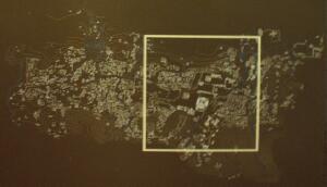
 This map of the entire complex shows the 2
square kilometers size of the city by the year 750 A.D. when it had a
calculated population of around 8,000 people. This places Palenque among
the most densely populated cities of Mezoamerica - around 4 people per
square meter. Some researchers associate this high population density with
the weakening of the local dynasty. The city was abandoned 150 years later.
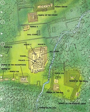
 The ceremonial center may
be divided into three major areas:
1) an open area bounded by the Temple of the Inscriptions, the west facade of the Palace and the unexcavated mound Temple XI;
2) separated from Area 1 by the canalized and partly vaulted Arroyo Otulum and, at a significantly higher elevation, an area bounded by the Temple of the Sun, the Temple of the Cross and the Temple of the Foliated Cross;
3) an area somewhat lower in elevation than Area 1, including the Ball Court and the Temple of the Count, bounded by the north facade of the Palace, Temple X, and the North Group.
Temple XII, Temple XIII, and Temple of the Inscriptions
Palace
Temple of the Sun, Temple of the Cross, and Temple of the Foliated Cross
All pictures are jpeg (jpg) 24-bits, 144 dpi format with 1024 pixels in the largest dimension. Higher resolution pictures are generally available, up to 1712 x 1368, as tif, jpeg/jpg, gif, tga, png, pcx, or bmp formats. Please email me if you are interested in these other formats.


